Research
Interdisciplinary research based on two pillars with five research units
A rich and diverse
study area
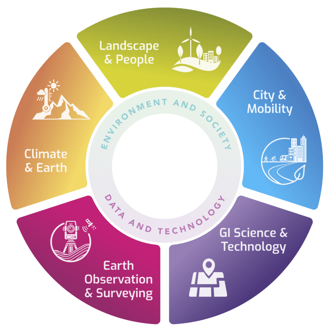
Geography / Geomatics research within the Department of Geography is based on two fundamental research pillars: Environment an Society and Data and Technology.
Together, these pillars not only contribute to understanding the world, but also provide valuable perspectives that offer sustainable solutions to various challenges.
Environment and Society
Data and Technology
Research Units
Research within the 2 research pillars (Environment and Society; Data and Technology) is conducted by 5 research units.
Each research unit consists of a professional team of professors and researchers, each with their individualities and areas of expertise.

Climate & Earth
Focus on human-environment interactions in the context of a changing environment and climate.
Research unit "Climate & Earth"
Landscape & People
The holistic and interdisciplinary approach to landscape, integration of a wide variety of topics, characterized by regional and spatial differentiation.
Research unit "Landscape and People"

City & Mobility
Displacement behavior, urban logistics, urban policy, world city network, land use modeling and location decisions.
Research unit "City & Mobility"
GI Science & Technology
The use of modern methods and the development of innovative technologies in multidisciplinary projects in the field of cartography and GIS.
Research unit "GI Science & Technology"

Earth Observation & Surveying
Collection of terrestrial data using drones, topographic and photogrammetric devices, remote sensing, photogrammetry, bathymetry, among others.
Research unit "Earth Observation & Surveying"
An experienced and dedicated team of professors, researchers and collaborators
The Geography Department's research team contributes a wealth of knowledge and expertise within a broad range of geographic disciplines.
In addition to studying numerous contemporary and historical geographical issues, the team works closely to explore, map and address some of the most pressing environmental and social challenges of our time.
Meet the cycling professor for Flanders!
Thanks to the new Chair of Cycling (City & Mobility), Flanders has recently also had its own cycling professor, Dr. Meredith Glaser.
With this new chair, the Flemish government and UGent want to further strengthen the ambitious Flemish cycling policy with academic knowledge and insights.

Leading scientific output
The Department of Geography is known for its prolific scholarly output, including numerous journal publications and dissertations.
With nationally and internationally funded projects, researchers are continually contributing to leading academic journals, sharing groundbreaking findings and promoting geographic science in general.
At your service
For questions, comments,... about research within the
Department of Geography you can always contact us.